
Suggested Day By Day Itinerary With Accommodations
The Itinerary Quotation is based on the below itinerary and includes the below suggested accommodation. You can change the suggested accommodations by selecting an Alternative Accommodation on the "ACCOMMODATIONS" to make the safari more Luxurious or Affordable. Also check out optional activities if any catches your eye, let us know and we will include it.
Like what you see? Let's make it happen...
Customize this itinerary to fit your Taste, Schedule and Budget..
YOUR EXPEDITION STARTS HERE
⋮
⋮
Day 1:
Windhoek - Sossusvlei
Welcome to Namibia! After meeting your guide, at the airport we will start making our way to our first destination; iconic Sossusvlei.
Reaching our accommodation in Sossusvlei, After lunch and settling in at our accommodation we will depart for a late afternoon nature drive in the beautiful surrounding area. Our accommodation for tonight is in an area perfectly situated to explore the surrounding desert and its many attractions.
Reaching our accommodation in Sossusvlei, After lunch and settling in at our accommodation we will depart for a late afternoon nature drive in the beautiful surrounding area. Our accommodation for tonight is in an area perfectly situated to explore the surrounding desert and its many attractions.
DAY ACTIVITIES
Drive From Windhoek To Sossusvlei
We will drive through the Khomas Highland and down the escarpment via one of the many scenic mountai... READ MORE
We will drive through the Khomas Highland and down the escarpment via one of the many scenic mountain passes into the Namib Desert. This journey will take about 4 to 5 hours, depending on the number of stops for photographs. We will certainly start seeing some of Namibia’s fantastic fauna and flora along the way, including Common Ostrich, Gemsbok, Pale Chanting Goshawk, Sociable Weavers or even a Greater Kudu.
We will reach our accommodation in the afternoon and if there is time it might be fun to walk around the lodge grounds looking for interesting smaller fauna and local flora. Our accommodation for tonight is in an area perfectly situated to explore the surrounding desert and its many attractions.
We will reach our accommodation in the afternoon and if there is time it might be fun to walk around the lodge grounds looking for interesting smaller fauna and local flora. Our accommodation for tonight is in an area perfectly situated to explore the surrounding desert and its many attractions.
READ LESS
OPTIONAL ACTIVITIES LIST IN:
OVERNIGHT & MEAL PLAN
Namib Desert Lodge Camping2go

NAMIBIA
+ 6 Images


LOCATION :
Sossusvlei
MEALS PLAN: FB - Dinner, Breakfast and Lunch


+ 4 Images


⋮
CONTINUE TO SWAKOPMUND
⋮
CONTINUE TO SWAKOPMUND
⋮
Day 2:
Sossusvlei - Swakopmund
After an early breakfast we will depart for an exciting morning excursion to Sossusvlei and nearby Dead Vlei, where we will spend a couple of hours on. After lunch we will depart for the coastal town of Swakopmund, driving through the vast Namib-Naukluft Park to get there. It is a beautiful drive of about 4 hours, and if time allows we will stop for the famous Apple Pie in the small desert oasis town of Solitaire, a true Namibian tradition that should not be missed.
DAY ACTIVITIES
Morning Sossusvlei Excursion
Sossusvlei itself is actually the pan or valley floor that we will park our vehicle on, and is surro... READ MORE
Sossusvlei itself is actually the pan or valley floor that we will park our vehicle on, and is surrounded by massive dunes on almost all sides. We will have plenty of time to enjoy some of the many highlights that surrounds Sossusvlei itself:
Dune 45- The most photographed dune on earth (situated 45 km past Sesriem on the road to Sossusvlei);
Hiddenvlei - Perfect if you are looking for solitude in the desert;
The magnificently tall Big Daddy dune;
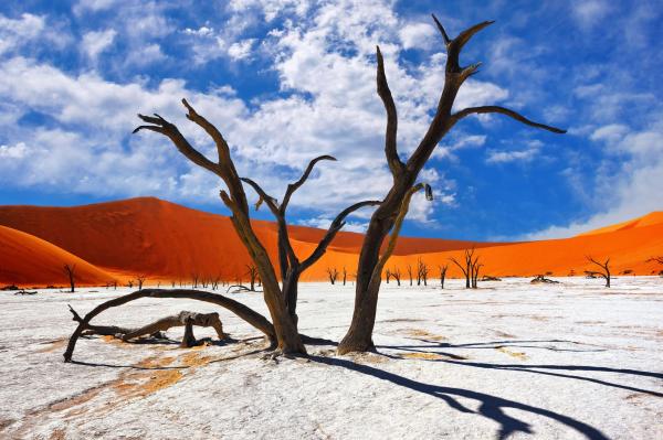
Deadvlei- A paradise for photographers, as it is punctuated by blackened, dead acacia trees, in vivid contrast to the shiny white of the salty floor of the pan and the intense orange of the dunes;
Sesriem Canyon- A narrow gorge of 1 km long and up to 30 m deep slashed into the earth by the Tsauchab river millions of years ago. The name derives from the Afrikaans for the 6 lengths of ropes that were needed to haul water out of the gorge to the top with containers in days gone by.
Dune 45- The most photographed dune on earth (situated 45 km past Sesriem on the road to Sossusvlei);
Hiddenvlei - Perfect if you are looking for solitude in the desert;
The magnificently tall Big Daddy dune;
Deadvlei- A paradise for photographers, as it is punctuated by blackened, dead acacia trees, in vivid contrast to the shiny white of the salty floor of the pan and the intense orange of the dunes;
Sesriem Canyon- A narrow gorge of 1 km long and up to 30 m deep slashed into the earth by the Tsauchab river millions of years ago. The name derives from the Afrikaans for the 6 lengths of ropes that were needed to haul water out of the gorge to the top with containers in days gone by.
READ LESS
Sossusvlei To Swakopmund
It is a beautiful drive of about 4 hours, and if time allows we will stop for the famous Apple Pie i... READ MORE
It is a beautiful drive of about 4 hours, and if time allows we will stop for the famous Apple Pie in the small desert oasis town of Solitaire, a true Namibian tradition that should not be missed.
Our drive this afternoon is wholly in the Namib Sand Sea, one of Namibia’s two UNESCO World Heritage Sites. It is the only coastal desert in the world that includes extensive dune fields influenced by fog. Covering an area of over three million hectares, the site features gravel plains, coastal flats and rocky hills within the sand sea, a coastal lagoon and ephemeral rivers, resulting in a landscape of exceptional beauty. Fog is the primary source of water in the site, accounting for a unique environment in which endemic invertebrates, reptiles and mammals adapt to an ever-changing variety of microhabitats and ecological niches.
Swakopmund is a very popular holiday destination for many Namibians and will probably be the only place that you will visit on the Namibian safari that has a real town feel to it. We will spend the night at a hotel and have dinner at one of the top restaurants in Swakopmund. Please note that dinner tonight is not included in the package price and is for your own account.
Our drive this afternoon is wholly in the Namib Sand Sea, one of Namibia’s two UNESCO World Heritage Sites. It is the only coastal desert in the world that includes extensive dune fields influenced by fog. Covering an area of over three million hectares, the site features gravel plains, coastal flats and rocky hills within the sand sea, a coastal lagoon and ephemeral rivers, resulting in a landscape of exceptional beauty. Fog is the primary source of water in the site, accounting for a unique environment in which endemic invertebrates, reptiles and mammals adapt to an ever-changing variety of microhabitats and ecological niches.
Swakopmund is a very popular holiday destination for many Namibians and will probably be the only place that you will visit on the Namibian safari that has a real town feel to it. We will spend the night at a hotel and have dinner at one of the top restaurants in Swakopmund. Please note that dinner tonight is not included in the package price and is for your own account.
READ LESS
OVERNIGHT & MEAL PLAN
Swakopmund Sands Hotel

NAMIBIA
+ 6 Images


LOCATION :
Swakopmund
MEALS PLAN: FB - Dinner, Breakfast and Lunch


+ 8 Images


⋮
EXPLORE SWAKOPMUND
⋮
EXPLORE SWAKOPMUND
⋮
Day 3:
Living Desert Experience
After breakfast in Swakopmund we will depart for a half day Living Desert Experience, a unique adventure indeed!
Once we are back in Swakopmund we will enjoy lunch and explore the town with optional activities like quad-biking, sandboarding or a scenic flight over the area. Swakopmund has made a name for itself as the activity and sport capital of Namibia, but this town offers so much more. Sandwiched between the hot, arid desert and the cold waters of the Atlantic, Swakop (as the locals call it) is one of the most fascinating colonial towns in all of Africa. It is a heady mix of South African, Namibian and German cultures, architecture, languages and cuisine. It is also the most popular tourist town in the country, with both locals and foreigners loving the laid-back atmosphere, good restaurants, many activities and the temperate climate.
Once we are back in Swakopmund we will enjoy lunch and explore the town with optional activities like quad-biking, sandboarding or a scenic flight over the area. Swakopmund has made a name for itself as the activity and sport capital of Namibia, but this town offers so much more. Sandwiched between the hot, arid desert and the cold waters of the Atlantic, Swakop (as the locals call it) is one of the most fascinating colonial towns in all of Africa. It is a heady mix of South African, Namibian and German cultures, architecture, languages and cuisine. It is also the most popular tourist town in the country, with both locals and foreigners loving the laid-back atmosphere, good restaurants, many activities and the temperate climate.
DAY ACTIVITIES
Swakopmund Living Desert Tours
We will encounter and learn more about the fascinating wildlife of the Namib Desert with the help of... READ MORE
We will encounter and learn more about the fascinating wildlife of the Namib Desert with the help of a local expert. We will look for geckos, scorpions, snakes, lizards, birds and beetles as well as the incredible plant life that survives in this harsh and seemingly inhospitable environment. Some of the special creatures we might see include Namib Sand Gecko, Namaqua Chameleon, Shovel-snouted Lizard, Tractrac Chat and even Peringuey’s or Horned Adder.
The Living Desert Tour is a unique 4x4 adventure which specializes in bringing the desert to life while sharing the awesome beauty of the Namib Desert with travellers from all over the world. The coastal dune belt may seem barren and lifeless to many people, but in fact it is alive with a fascinating variety of little desert adapted animals, which are able to survive on the life-giving fog which consistently rolls in from the cold Atlantic Ocean.
Come see the Dancing White Lady Spider (Carparachne aureoflava) cartwheel 44 turns per second down a dune to escape the enemy. Admire the transparent Namib Dune Gecko (Pachydactylus rangei) with webbed feet that are equivalent to snow shoes. Learn about the different beetles and insects and how they survive in the dune desert. Follow in the tracks of a legless Lizard (Fitsimmon’s Burrowing Skink), observe Sand Diving Lizards (Meroles Anchieta) dancing on the hot sand, Sidewinder Snakes (Perinquey’s Adder), Desert Chameleons and many more fascinating creatures. Learn about the geology, structure and formation of the desert, and admire the vast and beautiful landscapes while enjoying a scenic dune drive combined with fun and adrenalin.
The Living Desert Tour is a unique 4x4 adventure which specializes in bringing the desert to life while sharing the awesome beauty of the Namib Desert with travellers from all over the world. The coastal dune belt may seem barren and lifeless to many people, but in fact it is alive with a fascinating variety of little desert adapted animals, which are able to survive on the life-giving fog which consistently rolls in from the cold Atlantic Ocean.
Come see the Dancing White Lady Spider (Carparachne aureoflava) cartwheel 44 turns per second down a dune to escape the enemy. Admire the transparent Namib Dune Gecko (Pachydactylus rangei) with webbed feet that are equivalent to snow shoes. Learn about the different beetles and insects and how they survive in the dune desert. Follow in the tracks of a legless Lizard (Fitsimmon’s Burrowing Skink), observe Sand Diving Lizards (Meroles Anchieta) dancing on the hot sand, Sidewinder Snakes (Perinquey’s Adder), Desert Chameleons and many more fascinating creatures. Learn about the geology, structure and formation of the desert, and admire the vast and beautiful landscapes while enjoying a scenic dune drive combined with fun and adrenalin.
READ LESS
OPTIONAL ACTIVITIES LIST IN:
OVERNIGHT & MEAL PLAN
Swakopmund Sands Hotel
NAMIBIA
+ 6 Images
LOCATION :
Swakopmund
MEALS PLAN: FB - Dinner, Breakfast and Lunch


+ 4 Images
⋮
CONTINUE TO TWYFELFONTEIN
⋮
CONTINUE TO TWYFELFONTEIN
⋮
Day 4:
Skeleton Coast
This morning after breakfast we continue our safari northwards along the Skeleton Coast for a thrilling skeleton coast and Damaraland Tour. We will be at our lodge in time for a sundowner drink while we enjoy the view over this rugged but beautiful landscape.
DAY ACTIVITIES
Skeleton Coast And Damaraland Tour
This bleak and evocatively named area is one of the most unusual coastal wildernesses on the planet,... READ MORE
This bleak and evocatively named area is one of the most unusual coastal wildernesses on the planet, protecting about a third of Namibia’s long coastline.
After visiting one of the many shipwrecks along the coast for some dramatic photographs, we will turn inland towards spectacular Damaraland. We will drive past the Brandberg, Namibia’s highest mountain. In the distance we will also see the Spitzkoppe (sharp head), one of Namibia’s most recognizable landmarks.
This beautiful mountainous region is home to an assortment of scientifically important desert-adapted wildlife such as elephant, rhino, zebra and lion, which somehow survive and thrive in this near-barren landscape. We hope to see some of them; a special treat indeed!
After visiting one of the many shipwrecks along the coast for some dramatic photographs, we will turn inland towards spectacular Damaraland. We will drive past the Brandberg, Namibia’s highest mountain. In the distance we will also see the Spitzkoppe (sharp head), one of Namibia’s most recognizable landmarks.
This beautiful mountainous region is home to an assortment of scientifically important desert-adapted wildlife such as elephant, rhino, zebra and lion, which somehow survive and thrive in this near-barren landscape. We hope to see some of them; a special treat indeed!
READ LESS
OPTIONAL ACTIVITIES LIST IN:
OVERNIGHT & MEAL PLAN
Twyfelfontein Country Lodge

NAMIBIA
+ 8 Images


LOCATION :
Twyfelfontein
MEALS PLAN: FB - Dinner, Breakfast and Lunch


+ 4 Images


⋮
EXPLORE TWYFELFONTEIN
⋮
EXPLORE TWYFELFONTEIN
⋮
Day 5:
Twyfelfontein Excursions
After an early breakfast we will visit Twyfelfontein, another UNESCO World Heritage Site. Meaning “uncertain spring†in Afrikaans, it is a massive open-air art gallery in the northwestern Kunene region that is of great interest to international rock art connoisseurs.
The 2,000-plus rock petroglyphs, estimated to be 6,000 years old, represent one of Africa’s largest and most noteworthy concentrations of rock art. Most of these well-preserved engravings represent rhinoceros. The site also includes depictions of elephant, ostrich and giraffe, as well as drawings of human and animal footprints, all done in red ochre. Here we will also look out for the Namib Desert’s weird-looking living fossil plant, the Welwitschia.
We will spend about one hour on a guided walk amongst hundreds of engravings before we will continue northwards towards Kaokoland. This area is famous for the desert adapted elephants and Black Rhinos as well as the Himba people, Namibia’s last true nomadic tribe.
We will reach our lodge just in time for lunch. It is situated within one of Namibia’s best-run conservancies in an area between Kaokoland and the Skeleton Coast, where the flat-topped Etendeka mountains and the carpet of rich red rock greet the tributaries of the Uniab River. The lodge overlooks the sweeping northern Damaraland landscape peppered with green euphorbias. It truly is a beautiful place!
After lunch we will depart for an afternoon game drive in Palmwag Concession. Upon returning to our lodge we will enjoy a great dinner while going over the plan for tomorrow’s exciting rhino tracking activity.
The 2,000-plus rock petroglyphs, estimated to be 6,000 years old, represent one of Africa’s largest and most noteworthy concentrations of rock art. Most of these well-preserved engravings represent rhinoceros. The site also includes depictions of elephant, ostrich and giraffe, as well as drawings of human and animal footprints, all done in red ochre. Here we will also look out for the Namib Desert’s weird-looking living fossil plant, the Welwitschia.
We will spend about one hour on a guided walk amongst hundreds of engravings before we will continue northwards towards Kaokoland. This area is famous for the desert adapted elephants and Black Rhinos as well as the Himba people, Namibia’s last true nomadic tribe.
We will reach our lodge just in time for lunch. It is situated within one of Namibia’s best-run conservancies in an area between Kaokoland and the Skeleton Coast, where the flat-topped Etendeka mountains and the carpet of rich red rock greet the tributaries of the Uniab River. The lodge overlooks the sweeping northern Damaraland landscape peppered with green euphorbias. It truly is a beautiful place!
After lunch we will depart for an afternoon game drive in Palmwag Concession. Upon returning to our lodge we will enjoy a great dinner while going over the plan for tomorrow’s exciting rhino tracking activity.
DAY ACTIVITIES
Twyfelfontein Rock Engravings
The Twyfelfontein rock engravings are the most significant rock-engraving site in Namibia. More than... READ MORE
The Twyfelfontein rock engravings are the most significant rock-engraving site in Namibia. More than 2,500 engravings are found at 17 main sites, as well as several rock paintings. Its one of four top rock art sites in Southern Africa, the home of ancient mankind.
Especially interesting are large images of elephant, rhino, and a lion with spoor instead of paws, and human feet. There are two main routes. A shorter trail taking in some 5 sites & taking about ¾ hour to walk around. A longer trail which takes in 8 sites & will take about 1 hour to complete accompanied by a local guide to explain the stories behind each incredible etching.
Especially interesting are large images of elephant, rhino, and a lion with spoor instead of paws, and human feet. There are two main routes. A shorter trail taking in some 5 sites & taking about ¾ hour to walk around. A longer trail which takes in 8 sites & will take about 1 hour to complete accompanied by a local guide to explain the stories behind each incredible etching.
READ LESS
Organ Pipes
Nearby Burnt Mountain, a brilliantly coloured mountain of maroon, black & charcoal, a rock was forme... READ MORE
Nearby Burnt Mountain, a brilliantly coloured mountain of maroon, black & charcoal, a rock was formed 120 million years ago when a large sheet of black magma forced its way into carbonaceous shale. Nearby is an outcrop of volcanic rock called the Organ Pipes, a mass of perpendicular slabs of basalt between 130 & 150 million years old.
READ LESS
Petrified Forest
A visit to the fossilized tree trunks is equally absorbing. The stone ‘trees’ lying on ... READ MORE
A visit to the fossilized tree trunks is equally absorbing. The stone ‘trees’ lying on the ground are so well preserved they seem like logs. The Petrified Forest consists of at least 50 trees which are between 240 & 300 million years old.
Here you will also find one of the world’s botanical curiosities, the strange-looking Welwitschia. Although it does not resemble a tree at all, the Welwitschia is nevertheless classified as one, & much of its stem is underground. Only 2 leathery leaves of up to 8m long & 1,5m wide are produced on the gnarled stem, but the leaves are shredded by searing winds & extreme temperatures into a tangled mass, creating the impression of a multitude of leaves.
Here you will also find one of the world’s botanical curiosities, the strange-looking Welwitschia. Although it does not resemble a tree at all, the Welwitschia is nevertheless classified as one, & much of its stem is underground. Only 2 leathery leaves of up to 8m long & 1,5m wide are produced on the gnarled stem, but the leaves are shredded by searing winds & extreme temperatures into a tangled mass, creating the impression of a multitude of leaves.
READ LESS
Palmwag Concession Game Drive
Game drive in the 600,000 hectare Palmwag concession, looking for African Elephant, Gemsbok, Springb... READ MORE
Game drive in the 600,000 hectare Palmwag concession, looking for African Elephant, Gemsbok, Springbok, Chacma Baboon, Giraffe, Steenbok, Hartmann’s Mountain Zebra and Lion. This area is also great for seeing many of Namibia’s near-endemic birds like Monteiro’s and Damara Red-billed Hornbill, Ruppell’s Parrot, Benguela Long-billed Lark and Ruppell’s Korhaan.
READ LESS
OVERNIGHT & MEAL PLAN

+ 15 Images


LOCATION :
MEALS PLAN: FB - Dinner, Breakfast and Lunch


+ 12 Images


⋮
EXPLORE TWYFELFONTEIN
⋮
EXPLORE TWYFELFONTEIN
⋮
Day 6:
Kaokoland’s Black Rhinos Trekking
Today will be one of the highlights of the safari! After an early breakfast we will depart and dedicate most of the day in tracking down one of Kaokoland’s Black Rhinos that call this beautiful but harsh habitat home.
Depending on what time we get back to the lodge there might be time for an additional activity like a sundowner nature drive or a horseback trail. Since we cannot be sure what time we will return none of the extra activities are included and can be arranged at the lodge.
We will again stay at the same lodge and enjoy a well-deserved dinner and night’s rest after a full day in the Kaokoland bush.
Depending on what time we get back to the lodge there might be time for an additional activity like a sundowner nature drive or a horseback trail. Since we cannot be sure what time we will return none of the extra activities are included and can be arranged at the lodge.
We will again stay at the same lodge and enjoy a well-deserved dinner and night’s rest after a full day in the Kaokoland bush.
DAY ACTIVITIES
Kaokoland's Black Rhinos Trekking
Black Rhinos are native to eastern and southern Africa, and although the animal is referred to as bl... READ MORE
Black Rhinos are native to eastern and southern Africa, and although the animal is referred to as black, its colours vary from brown to grey. Unlike other Black Rhino populations, the ones of this region of Namibia are usually unsociable, tending to live in small groups. A mother will remain with her calf for around two and a half years. Enough time for the youngster to obtain all the vital methods of surviving in one of the toughest habitats on the planet!
These specially adapted individuals can withstand scorching heat; in excess of 40°C (100°F), but can also cope with the below freezing temperatures common after dark in Namibia’s arid regions. Black Rhinos are least active during the heat of the day (between 10am and 3pm) when they take to the shade of large rocks. They become more active after dark when the temperatures drop.
Black Rhinos are browsers (i.e. they eat trees, bushes and shrubs), as opposed to their White Rhino cousins, which are grazers. Remarkably, the Namib Desert Black Rhino has evolved to survive without water for 2 or 3 days! The population density of the Black Rhino in the desert plains of northwestern Namibia is one rhino per 100 km2, and still the Black Rhinos in Namibia make up to one third of the world’s remaining rhino population! That is a scary statistic.
The area where we will be walking and driving today holds the only population of Black Rhinoceros outside a protected area anywhere in the world. They do cover huge distances in search of food and water and have big territories so it might take a great tracking effort to find them. During the tracking we will encounter various other species of game including Gemsbok, Springbok, Hartmann’s Mountain Zebra and hopefully also African Elephant.
These specially adapted individuals can withstand scorching heat; in excess of 40°C (100°F), but can also cope with the below freezing temperatures common after dark in Namibia’s arid regions. Black Rhinos are least active during the heat of the day (between 10am and 3pm) when they take to the shade of large rocks. They become more active after dark when the temperatures drop.
Black Rhinos are browsers (i.e. they eat trees, bushes and shrubs), as opposed to their White Rhino cousins, which are grazers. Remarkably, the Namib Desert Black Rhino has evolved to survive without water for 2 or 3 days! The population density of the Black Rhino in the desert plains of northwestern Namibia is one rhino per 100 km2, and still the Black Rhinos in Namibia make up to one third of the world’s remaining rhino population! That is a scary statistic.
The area where we will be walking and driving today holds the only population of Black Rhinoceros outside a protected area anywhere in the world. They do cover huge distances in search of food and water and have big territories so it might take a great tracking effort to find them. During the tracking we will encounter various other species of game including Gemsbok, Springbok, Hartmann’s Mountain Zebra and hopefully also African Elephant.
READ LESS
OPTIONAL ACTIVITIES LIST IN:
OVERNIGHT & MEAL PLAN
+ 15 Images
LOCATION :
MEALS PLAN: FB - Dinner, Breakfast and Lunch


⋮
CONTINUE TO EPUPA FALLS
⋮
CONTINUE TO EPUPA FALLS
⋮
Day 7:
Palmwag - Kunene Waterfalls
After an early breakfast we will continue our safari northwards towards the Kunene river, which forms Namibia’s northwestern border with Angola.
After settling in and a refreshing swim we will visit the famous Epupa falls for a thrilling experience.
We will enjoy dinner on a deck overlooking the river, with the sounds of falls remaining with us throughout the night.
After settling in and a refreshing swim we will visit the famous Epupa falls for a thrilling experience.
We will enjoy dinner on a deck overlooking the river, with the sounds of falls remaining with us throughout the night.
DAY ACTIVITIES
Palmwag - Kunene Waterfalls
The drive today will take a fairly long time depending on the number of stops for wildlife and sceni... READ MORE
The drive today will take a fairly long time depending on the number of stops for wildlife and scenic areas like a group of strange-looking Baobab trees together a very long way away from areas where they are known to occur. However, the long drive will be well worth it; this is an incredibly beautiful and dramatic area of the country.
Kunene is one of the fourteen official regions of Namibia and is located in the far northwestern corner of the country. It is roughly 115,000 square kilometres (45,000 square miles) big, with a population density of only 0.75 people per square kilometre (2 per square mile)! Kunene's western edge is the shores of the Atlantic ocean, and in the north it borders Angola's Namibe Province. Compared to the rest of Namibia, it is relatively underdeveloped. This is due to the mountainous inaccessible geography and the dryness that significantly hinders agriculture. It is, however, home to an abundance of wildlife. This includes a wealth of desert adapted wildlife, including the largest population of free-ranging Black Rhinoceros in the world, African Elephant, Lion, Cheetah, Leopard, Spotted Hyaena, Hartmann's Mountain Zebra, Springbok and Gemsbok.
The region gets its name from the 1,050 kilometre (650 miles) long perennial Kunene river, which forms the northern border with Angola. There are all sorts of exciting activities to be enjoyed on and long the river, from boat cruises and canoeing to white-water rafting and fishing. It is also a birdwatching hotspot, with many localised and highly prized species occurring here.
We will cross the Hoanib river valley before driving via the Frans Joubert pass. We will stop at Opuwo, the capital of Kaokoland, for fuel and lunch before driving the last 130km to our lodge on the banks of the Kunene River.
Kunene is one of the fourteen official regions of Namibia and is located in the far northwestern corner of the country. It is roughly 115,000 square kilometres (45,000 square miles) big, with a population density of only 0.75 people per square kilometre (2 per square mile)! Kunene's western edge is the shores of the Atlantic ocean, and in the north it borders Angola's Namibe Province. Compared to the rest of Namibia, it is relatively underdeveloped. This is due to the mountainous inaccessible geography and the dryness that significantly hinders agriculture. It is, however, home to an abundance of wildlife. This includes a wealth of desert adapted wildlife, including the largest population of free-ranging Black Rhinoceros in the world, African Elephant, Lion, Cheetah, Leopard, Spotted Hyaena, Hartmann's Mountain Zebra, Springbok and Gemsbok.
The region gets its name from the 1,050 kilometre (650 miles) long perennial Kunene river, which forms the northern border with Angola. There are all sorts of exciting activities to be enjoyed on and long the river, from boat cruises and canoeing to white-water rafting and fishing. It is also a birdwatching hotspot, with many localised and highly prized species occurring here.
We will cross the Hoanib river valley before driving via the Frans Joubert pass. We will stop at Opuwo, the capital of Kaokoland, for fuel and lunch before driving the last 130km to our lodge on the banks of the Kunene River.
READ LESS
OPTIONAL ACTIVITIES LIST IN:
OVERNIGHT & MEAL PLAN
Epupa Camp

NAMIBIA
+ 4 Images


LOCATION :
Epupa Falls
MEALS PLAN: FB - Dinner, Breakfast and Lunch


+ 4 Images


⋮
CONTINUE TO KUNENE RIVER
⋮
CONTINUE TO KUNENE RIVER
⋮
Day 8:
The Himba Experience
After a relaxing breakfast we will depart for a Himba village Experience visit.
After the visit we will depart for our next destination, about a 3 hour drive from Epupa. We will stay in a beautiful lodge overlooking the Kunene River.
For birdwatchers this area is highly rewarding. Some very special species occur here that are very difficult to see anywhere else in the southern African subregion. These include Rufous-tailed Palm Thrush, Grey Kestrel, Cinderella Waxbill and Angolan Swallow.
After lunch and couple of hours to relax we will depart for an afternoon and sundowner cruise on the Kunene River before enjoying dinner on the deck overlooking the river.
After the visit we will depart for our next destination, about a 3 hour drive from Epupa. We will stay in a beautiful lodge overlooking the Kunene River.
For birdwatchers this area is highly rewarding. Some very special species occur here that are very difficult to see anywhere else in the southern African subregion. These include Rufous-tailed Palm Thrush, Grey Kestrel, Cinderella Waxbill and Angolan Swallow.
After lunch and couple of hours to relax we will depart for an afternoon and sundowner cruise on the Kunene River before enjoying dinner on the deck overlooking the river.
DAY ACTIVITIES
The Himba Experience
Known as the last true nomadic tribe of Namibia, the Himba has a unique and wonderful culture. The H... READ MORE
Known as the last true nomadic tribe of Namibia, the Himba has a unique and wonderful culture. The Himba, who currently number between 30,000 and 50,000 individuals, have been plagued by severe droughts, guerrilla warfare (during Namibian independence and the Angolan civil war) and the German forces that decimated other groups in Namibia. Despite Himba life nearly coming to a close in the 1980s, they have persevered and their people, culture and tradition remain.
Himba women are known for their unusual sculptured beauty, enhanced by their complex hairstyles and traditional beautifications. In the Himba culture a sign of wealth is the cattle you had owned during your lifetime, represented by the horns on your grave. The cattle are therefore kept as a sign of wealth, whereas the sheep and goats are bred for food. Only occasionally are the livestock sold for cash.
We will spend a couple of hours learning about their history, culture and get an insight into their daily lives.
Himba women are known for their unusual sculptured beauty, enhanced by their complex hairstyles and traditional beautifications. In the Himba culture a sign of wealth is the cattle you had owned during your lifetime, represented by the horns on your grave. The cattle are therefore kept as a sign of wealth, whereas the sheep and goats are bred for food. Only occasionally are the livestock sold for cash.
We will spend a couple of hours learning about their history, culture and get an insight into their daily lives.
READ LESS
OPTIONAL ACTIVITIES LIST IN:
OVERNIGHT & MEAL PLAN
Kunene River Lodge

NAMIBIA
+ 6 Images


LOCATION :
Kunene River
MEALS PLAN: FB - Dinner, Breakfast and Lunch


+ 4 Images


⋮
CONTINUE TO ETOSHA NATIONAL PARK
⋮
CONTINUE TO ETOSHA NATIONAL PARK
⋮
Day 9:
Kunene to Western Etosha National Park
After breakfast we will proceed from Kunene towards Etosha National Park with astonishing views along the way.
We will arrive back at our lodge late in the afternoon and enjoy dinner, reminiscing about our wonderful trip so far. Remember to look up before settling into your bed tonight – the African night sky, undisturbed by city lights out here in the bush, is truly amazing.
We will arrive back at our lodge late in the afternoon and enjoy dinner, reminiscing about our wonderful trip so far. Remember to look up before settling into your bed tonight – the African night sky, undisturbed by city lights out here in the bush, is truly amazing.
DAY ACTIVITIES
Kunene To Western Etosha National Park
We will slowly make our way eastwards along the Kunene River until we reach the Ruacana Falls. The w... READ MORE
We will slowly make our way eastwards along the Kunene River until we reach the Ruacana Falls. The waterfall is 120 meters (390 ft) high and 700 meters (2,300 ft) wide in full flood. It is among the largest waterfalls in Africa, both by volume and width. We will spend some time here depending on the water level.
From here we will make our way south until we reach the Galton gate of Etosha National Park. Undoubtedly one of the great parks of Africa, Etosha covers more than 22,300 km2 (8,620 sq mi) and is synonymous with big game and wide open spaces. The name Etosha actually means “great white place†referring to the massive (130km long and 50km wide) dry saline pan in the middle of the park, believed to have been formed over 100 million years ago.
We will stay in Dolomite Camp, a new camp in the western section of Etosha. Until a few years back this section was closed to the public and with the rolling dolomite hills offers a unique and completely different habitat to the rest of Etosha. After enjoying lunch at our lodge which is situated on top of a hill with wonderful views over the surrounding plains, we will do an afternoon game drive.
Because of the different habitat we will encounter species like Hartmann’s Mountain Zebra and Roan Antelope together with the general Etosha species. African Elephant, Lion, Gemsbok, Greater Kudu, Hartebeest and Burchell’s Zebra are present in good numbers in this section of Etosha.
From here we will make our way south until we reach the Galton gate of Etosha National Park. Undoubtedly one of the great parks of Africa, Etosha covers more than 22,300 km2 (8,620 sq mi) and is synonymous with big game and wide open spaces. The name Etosha actually means “great white place†referring to the massive (130km long and 50km wide) dry saline pan in the middle of the park, believed to have been formed over 100 million years ago.
We will stay in Dolomite Camp, a new camp in the western section of Etosha. Until a few years back this section was closed to the public and with the rolling dolomite hills offers a unique and completely different habitat to the rest of Etosha. After enjoying lunch at our lodge which is situated on top of a hill with wonderful views over the surrounding plains, we will do an afternoon game drive.
Because of the different habitat we will encounter species like Hartmann’s Mountain Zebra and Roan Antelope together with the general Etosha species. African Elephant, Lion, Gemsbok, Greater Kudu, Hartebeest and Burchell’s Zebra are present in good numbers in this section of Etosha.
READ LESS
OPTIONAL ACTIVITIES LIST IN:
OVERNIGHT & MEAL PLAN
Dolomite Camp

NAMIBIA
+ 5 Images


LOCATION :
Etosha National Park
MEALS PLAN: FB - Dinner, Breakfast and Lunch


+ 4 Images


⋮
EXPLORE ETOSHA NATIONAL PARK
⋮
EXPLORE ETOSHA NATIONAL PARK
⋮
Day 10:
Full Day West Etosha Game Drive
After breakfast we will slowly make our way towards Okaukuejo in the western side of the Etosha park. We have a full day to enjoy all that this fantastic wildlife reserve has to offer.
We will arrive at our camp after an afternoon game drive and relax. Okaukuejo is one of Etosha’a most popular camps and the surrounding plains and waterholes are brilliant for game viewing. The floodlit waterhole on the edge of the camp allows for game viewing long after the sun has set.
We will arrive at our camp after an afternoon game drive and relax. Okaukuejo is one of Etosha’a most popular camps and the surrounding plains and waterholes are brilliant for game viewing. The floodlit waterhole on the edge of the camp allows for game viewing long after the sun has set.
DAY ACTIVITIES
Etosha National Park Game Drives
Etosha National Park in northern Namibia offers you the chance to spot game in a wonderful natural s... READ MORE
Etosha National Park in northern Namibia offers you the chance to spot game in a wonderful natural setting. Enjoy a fascinating African wildlife adventure in Namibia in search of wildlife like megaherbivores such as giraffe, elephant black and white rhino as well as predators like lion, cheetah and leopard.
Travel from waterhole to waterhole and observe as herds of elephants slowly make their way towards the waterhole right in front of you. One elephant first checks out if the waterhole is safe, then the whole herd, with babies in tow, follows. You may see them putting their trunks in the muddy water and spraying themselves until they look white.
The park itself covers 22,270 kms², and gets its name from the salt pan that makes up approx. 23% of the park. Once a massive lake, the Etosha Pan is now mostly dry, with the exception of good rainfall years when the pan fills up enough to become a breeding ground for flamingos that migrate between Walvis Bay and Sua Pan in Botswana
Etosha is home to 114 mammal species, 340 bird species, a variety of reptiles and even 1 species of fish. The game viewing is diverse and due to the dry nature of the region it is not uncommon to spot multiple species (including both predators and prey) hanging around the same waterhole.
Travel from waterhole to waterhole and observe as herds of elephants slowly make their way towards the waterhole right in front of you. One elephant first checks out if the waterhole is safe, then the whole herd, with babies in tow, follows. You may see them putting their trunks in the muddy water and spraying themselves until they look white.
The park itself covers 22,270 kms², and gets its name from the salt pan that makes up approx. 23% of the park. Once a massive lake, the Etosha Pan is now mostly dry, with the exception of good rainfall years when the pan fills up enough to become a breeding ground for flamingos that migrate between Walvis Bay and Sua Pan in Botswana
Etosha is home to 114 mammal species, 340 bird species, a variety of reptiles and even 1 species of fish. The game viewing is diverse and due to the dry nature of the region it is not uncommon to spot multiple species (including both predators and prey) hanging around the same waterhole.
READ LESS
OPTIONAL ACTIVITIES LIST IN:
OVERNIGHT & MEAL PLAN
Okaukuejo Resort

NAMIBIA
+ 8 Images


LOCATION :
Etosha National Park
MEALS PLAN: FB - Dinner, Breakfast and Lunch


+ 4 Images
⋮
EXPLORE ETOSHA NATIONAL PARK
⋮
EXPLORE ETOSHA NATIONAL PARK
⋮
Day 11:
Etosha - Windhoek
After breakfast we will do a quick game drive before making our way back to Windhoek (5 to 6 hour drive) or continuing for an additional couple of nights in Etosha’s eastern section. Alternatively we can spend a night at the Waterberg Plateau National Park close to Otjiwarongo. Please contact us for suggestions on possible extensions.
In Windhoek we will take you to the Hosea Kutako International Airport for your homeward flight or for your connecting flight if you decide to combine this safari with an extension to the Caprivi, Victoria Falls, Botswana, Zambia or South Africa. We will gladly assist with accommodation in Windhoek should you need to stay over.
In Windhoek we will take you to the Hosea Kutako International Airport for your homeward flight or for your connecting flight if you decide to combine this safari with an extension to the Caprivi, Victoria Falls, Botswana, Zambia or South Africa. We will gladly assist with accommodation in Windhoek should you need to stay over.
작동 방식
1
당신의 꿈의 여행을 설명해주세요
2여행 컨설턴트가 여행 경험을 선별적으로 도와줄 것입니다.
3확인하고 짐 싸기 시작하기

X
Tour Start Dates
No. Of Adults (13+ Yrs)
No. Of Children (Below 12 yrs)
Accommodation Category